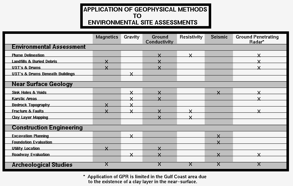
Environmental Geophysics, Inc. (EG) provides environmental site investigation and characterization services using the most current technologies available in the geophysical field. Dr. Mustafa Saribudak earned a MSc. in Geological Engineering and a Ph.D. in Geophysics. Previous to the establishment of EG, Dr. Saribudak pioneered the application of geophysical methods to environmental problems while at Tierra Environmental in the Woodlands, Texas. Services provided byEG can be categorized as environmental site assessment and construction engineering, which can be summarized below:
MICRO-MAGNETIC
MAP OF A DRUM SITE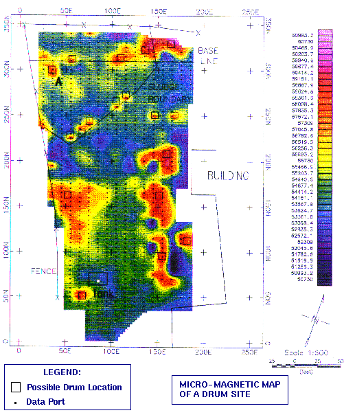
The objective of the micro-magnetic survey was to define the precise location of drums that were present beneath the surface. Magnetic anomalies outlined by orange and red colors indicate the location of drums. Three buried trenches with drums and barrels also were discovered by the magnetic survey at the site.
The result of the survey correclated very well with field data generated during excavation.
HORIZONTAL
DELINEATION OF BRINE CONTAMINATION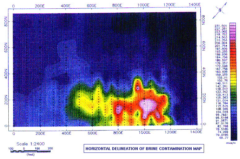
EG's ground conductivity survey has successfully delineated the horizontal extent of the salt water plume. The highest contamination is shown by pink, red, orange and yellow colors, pink being the highest. It is observed that the brine plume is migrating to the west from the source. The existing soil boring data strongly supports the conclusion reached in this study.
MICRO-MAGNETIC
MAP OF A DUMP SITE WITH AN UNDERGROUND STORAGE TANK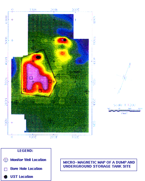
A preliminary environmental site assessment report on this location indicated that the groundwater-soil system was contaminated. The source for this contamination was attributed to two underground storage tanks (UST) that had been removed from the site and numerous UST's located on near-off site locations.
There were four monitoring wells installed on this site. In addition, four soil borings were previously drilled by an other environmental company to a depth of three feet. Samples taken from the borings indicated that the soil had contamination from heavy metals, such as barium, cadmium and lead.
Thus, the objective of our micro-magnetic survey was to determine the location of the UST's, which could still be present, and to delineate any covered, inactive dump location.
The following micro-magnetic map depicts a striking magnetic anomaly over the area where the soil borings were located. This anomaly is outlined by a red line and is indicative of a buried dump location. It appears, after having exchanged information with the client, that this magnetic feature is lcoated over the former metal salvage facility which was in operation many years ago.
In addition, two local magnetic anomalies, whose locations are shown by solid dots, are predicted to correspond to UST's. These two locations were drilled and UST's were recovered at a depth of ten feet, as magnetic modeling suggested.
MICRO-MAGNETIC
MAP OF A LANDFILL SITE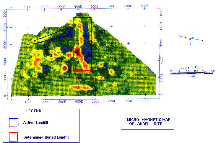
EG conducted a magnetic survey over this seven acre area to define the lateral and vertical extent of an inactive, buried landfill. The information collected from the site by other sources had not provided any clues as to where the buried landfill was located within the seven acres.
As indicated on the following magnetic map, an east-west magnetic anomaly exits whose approximate boundary is defined by a solid red line. This linear magnetic feature is a typical signature of a buried trench filled with highly ferrous materials. Outside the boundaries of the red line, there are isolated, local magnetic anomalies as shown by the yellow, orange and red colors. The source that is causing these anomalies is due to scattered, superficial debris that is located throughout the site. A computer modeling of the trench indicates that it vertically extends 15 feet.
After conducting our magnetic survey, it was determined that the buried landfill was located within a one acre area. A proper remediation plan for the site can now be established due to the information provided by our magnetic method.
![]()
Environmental Geophysics, Inc.
Email: mbudak@pdq.com;
Telephone: 713-370-7066 ; Facsimile: 713-370-7099
Environmental Geophysics, Inc. is a member of the HyperEdge Expert Association , a Virtual Corporation.
This Home Page was produced by Bob Horner. email - bhorner@hypermedia.com