 (Sean McQuaid)
This section is a `guide' to using seismic data for mapping lithology and
fluid
variations in your reservoir. It will help you reduce the risks in
hydrocarbon
exploitation.
It is organized as a series of flow charts which are applicable at all
stages
of exploration, appraisal, development and production. These will help
assess
the seismic and petrophysical data available, and will direct you to the
relevant seismic rock properties for mapping variations in reservoir
properties. The book will then guide you to the appropriate tool to use
for a
given problem. References are also made to relevant case histories and to
the
tools section to illustrate how these geophysical tools have been used
to map
reservoir properties.
Seismic data is predominantly used to correlate units between wells and
hence
map structural closure and thickness changes. In addition there are
three rock
properties that can be measured from seismic data. These are Acoustic
Impedance, Velocity and Poisson's Ratio. They can be used to provide
information on the internal geometry and reservoir properties of a
prospect.
This section will help you exploit this information allowing you to map
these
properties away from well control.
Firstly, you must have a clear understanding of the problem. For
example;
most Prospect or Field evaluation problems which can be solved using
seismic
techniques, fall into five generic catagories.
- Lithology Prediction e.g. Do my sands shale out away from the
well.
- Fluid Prediction e.g. Is this a gas sand or water sand.
- Porosity Estimation e.g. Would I expect good porosity in my
next
development well.
- Net Pay Estimation e.g. How does my Net Pay vary across the
field.
- Reservoir Heterogeneity e.g. Where shall I put my injection
well
These are all typical of the qualitative and quantitative
problems in
mapping reservoir properties that LFP have attempted to address.
Here is a logical path through the flowcharts. However, the starting
point
will depend on the user's experience.
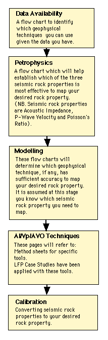
Logical Path